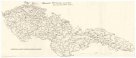
Geogr.-physik.-statist. Karte von Deutschland mit Einschluss von ganz Oesterreich, Belgien, den Niederlanden, der Schweiz, Italien und einem Theile von Frankreich, England, Russland und der Türkei
popis
obě strany, barev. 41 x 53 cm na listu 50 x 52 cm, v deskách 14 x 10 cm Měřítko 1:4 000 000 (001°42´49" v.d.--030°56´14" v.d./056°59´34" s.š.--041°08´44" s.š.)
- instituce / organizační jednotka
- Mapová sbírka Přírodovědecké fakulty UK v Praze
- podsbírka
- Mapová sbírka
- typ sbírky
- Mapy
- alternativní název
- Reise- Geschäfts- und Schul-Karte der mittel-europäischen Staaten
- autor předmětu
- Haurand, Theodor C. W.
- datum vydání
- 1867
- jazyk dokumentu
- Němčina
- lokalita/místo vzniku
- Bez určení
- materiál
- Papír
- původ
- Razítko Museum Regni Bohemiae.
- inventární číslo
- 001398376
podobné předměty
-
 Mapová sbírka Přírodovědecké fakulty UK v PrazeŽelezniční síť Československé republiky z hlediska topografického
 -
 Mapová sbírka Přírodovědecké fakulty UK v PrazeSchema Jero Röm. Kaiserl. zu hung. u. Böhmen Königl. Majestät, regulirten Regmtr zu Fuß und zu Pferd
 -
 Mapová sbírka Přírodovědecké fakulty UK v PrazeSorokaverstnoj karty Turkestanskago vojennago okruga i sosědnich vladěnij
 -
![[Nový Hrádek].](/data/cache/media/bc/12275308-136x110-1707324291.jpg) Mapová sbírka Přírodovědecké fakulty UK v Praze[Nový Hrádek].
Mapová sbírka Přírodovědecké fakulty UK v Praze[Nový Hrádek]. -
![[Gablenz]](/data/cache/media/cd/12275294-136x110-1707324291.jpg) Mapová sbírka Přírodovědecké fakulty UK v Praze[Gablenz]
Mapová sbírka Přírodovědecké fakulty UK v Praze[Gablenz] -
![[Świdnica]](/data/cache/media/54/12275280-136x110-1707324291.jpg) Mapová sbírka Přírodovědecké fakulty UK v Praze[Świdnica]
Mapová sbírka Přírodovědecké fakulty UK v Praze[Świdnica] -
![[Niwica]](/data/cache/media/c4/12275266-136x110-1707324292.jpg) Mapová sbírka Přírodovědecké fakulty UK v Praze[Niwica]
Mapová sbírka Přírodovědecké fakulty UK v Praze[Niwica] -
![[Brzeźnica]](/data/cache/media/d8/12275252-136x110-1707324292.jpg) Mapová sbírka Přírodovědecké fakulty UK v Praze[Brzeźnica]
Mapová sbírka Přírodovědecké fakulty UK v Praze[Brzeźnica] -
![[Groß Düben]](/data/cache/media/93/12275238-136x110-1707324292.jpg) Mapová sbírka Přírodovědecké fakulty UK v Praze[Groß Düben]
Mapová sbírka Přírodovědecké fakulty UK v Praze[Groß Düben]