-
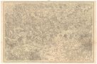
 Mapová sbírka Přírodovědecké fakulty UK v PrazeInternationale Weltkarte 1:1.000.000
 -
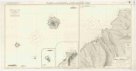
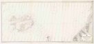
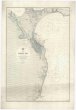
 Mapová sbírka Přírodovědecké fakulty UK v PrazeIsland of Saint Helena
 -
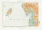
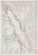
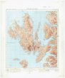 Mapová sbírka Přírodovědecké fakulty UK v PrazeIsland of Skye
 -
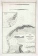
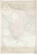
 Mapová sbírka Přírodovědecké fakulty UK v PrazeIslands and anchorages in the South Atlantic Ocean
 -
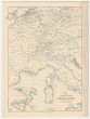
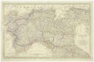 Mapová sbírka Přírodovědecké fakulty UK v PrazeItaly.
 -
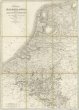 Mapová sbírka Přírodovědecké fakulty UK v PrazeKingdom of the Netherlands, including the Grand duchy of Luxembourg
 -
 Mapová sbírka Přírodovědecké fakulty UK v PrazeLand registry series.
 -
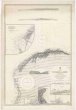
 Mapová sbírka Přírodovědecké fakulty UK v PrazeLofoten Island to Spitsbergen
 -
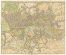
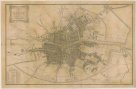
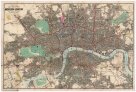
 Mapová sbírka Přírodovědecké fakulty UK v PrazeLondon
 -
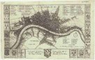
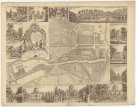
 Mapová sbírka Přírodovědecké fakulty UK v PrazeLuffman's faithful guide through London and places adjacent
 -
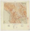
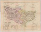
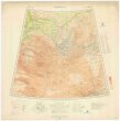
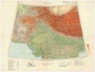
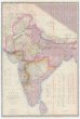 Mapová sbírka Přírodovědecké fakulty UK v PrazeMAP OF INDIA
 -
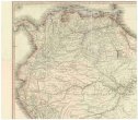 Mapová sbírka Přírodovědecké fakulty UK v PrazeMAPA Geografico DE AMERICA MERIDIONAL
 -
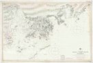 Mapová sbírka Přírodovědecké fakulty UK v PrazeMacao to Pedro Blanco including Hongkong
 -
 Mapová sbírka Přírodovědecké fakulty UK v PrazeMackenzie River to Bering Strait
 -
 Mapová sbírka Přírodovědecké fakulty UK v PrazeMalacca Strait with part of the east coast of the Malay Peninsula
 -
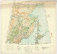
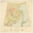 Mapová sbírka Přírodovědecké fakulty UK v PrazeManchuria
 -
 Mapová sbírka Přírodovědecké fakulty UK v PrazeManchuria
 -
 Mapová sbírka Přírodovědecké fakulty UK v PrazeMap exhibiting the great post roads, physical and political divisions of Europe
 -
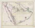 Mapová sbírka Přírodovědecké fakulty UK v PrazeMap of Arabia
 -
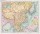 Mapová sbírka Přírodovědecké fakulty UK v PrazeMap of China, Burma, Siam, Annam & c.
 -
 Mapová sbírka Přírodovědecké fakulty UK v PrazeMap of Cook's tours in central Europe
 -
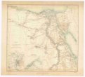 Mapová sbírka Přírodovědecké fakulty UK v PrazeMap of Egypt
 -
 Mapová sbírka Přírodovědecké fakulty UK v PrazeMap of Jamaica
 -
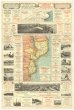 Mapová sbírka Přírodovědecké fakulty UK v PrazeMap of Portuguese East Africa
 -
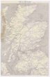 Mapová sbírka Přírodovědecké fakulty UK v PrazeMap of Scotland with railway routes
 -
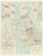
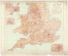
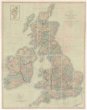 Mapová sbírka Přírodovědecké fakulty UK v PrazeMap of the British Isles
 -
 Mapová sbírka Přírodovědecké fakulty UK v PrazeMap of the Island of Jamaica
 -
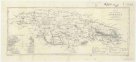
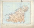
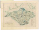 Mapová sbírka Přírodovědecké fakulty UK v PrazeMap of the Isle of Wight
 -
 Mapová sbírka Přírodovědecké fakulty UK v PrazeMap of the Oregon districts and the adjacent country
 -
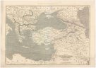 Mapová sbírka Přírodovědecké fakulty UK v PrazeMap of the Ottoman Empire, Kingdom of Greece, and the russian provinces on the Black Sea
 -
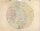 Mapová sbírka Přírodovědecké fakulty UK v PrazeMap of the countries round the North Pole
 -
 Mapová sbírka Přírodovědecké fakulty UK v PrazeMap of the county of Kent
 -
 Mapová sbírka Přírodovědecké fakulty UK v PrazeMaps of the society for the diffusion uf useful knowledge
 -
 Mapová sbírka Přírodovědecké fakulty UK v PrazeMaps of the society for the diffusion uf useful knowledge
 -
 Mapová sbírka Přírodovědecké fakulty UK v PrazeMarcus Ward's Shilling Map of the City of Belfast
 -
 Mapová sbírka Přírodovědecké fakulty UK v PrazeMediterranean
 -
 Mapová sbírka Přírodovědecké fakulty UK v PrazeMediterranean Sea
 -
 Mapová sbírka Přírodovědecké fakulty UK v PrazeMediterranean Sea, Libia
 -
Mapová sbírka Přírodovědecké fakulty UK v PrazeMediterranean Sea, Libia & Egypt
-
 Mapová sbírka Přírodovědecké fakulty UK v PrazeMediterranean Sea, Libya
 -
Mapová sbírka Přírodovědecké fakulty UK v PrazeMediterranean, Libia
-
Mapová sbírka Přírodovědecké fakulty UK v PrazeMediterranean, Libia
-
 Mapová sbírka Přírodovědecké fakulty UK v PrazeMediterranean, Libya
 -
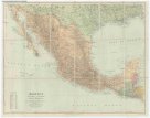 Mapová sbírka Přírodovědecké fakulty UK v PrazeMexico Guatemala, Salvador and British Honduras
 -
 Mapová sbírka Přírodovědecké fakulty UK v PrazeMiddlesex surrey
 -
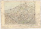
 Mapová sbírka Přírodovědecké fakulty UK v PrazeMongolia
 -
 Mapová sbírka Přírodovědecké fakulty UK v PrazeMongolia
 -
 Mapová sbírka Přírodovědecké fakulty UK v PrazeMoscow
 -
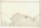
 Mapová sbírka Přírodovědecké fakulty UK v PrazeMouth of the Euphrates, Shatt al Arab and Bahmanshir river
 -
 Mapová sbírka Přírodovědecké fakulty UK v PrazeMunich
 -
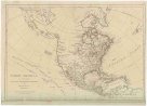 Mapová sbírka Přírodovědecké fakulty UK v PrazeNORTH AMERICA, AS DIVIDED amongst THE EUROPEAN POWERS
 -
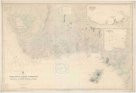
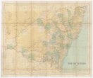 Mapová sbírka Přírodovědecké fakulty UK v PrazeNew South Wales
 -
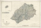
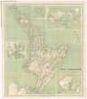 Mapová sbírka Přírodovědecké fakulty UK v PrazeNew Zealand
 -
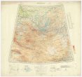
 Mapová sbírka Přírodovědecké fakulty UK v PrazeNord-Indien
 -
 Mapová sbírka Přírodovědecké fakulty UK v PrazeNorth America, east part
 -
 Mapová sbírka Přírodovědecké fakulty UK v PrazeNorth Amerika, west coast, Alaska
 -
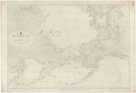
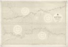
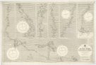
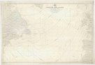 Mapová sbírka Přírodovědecké fakulty UK v PrazeNorth Atlantic
 -
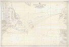 Mapová sbírka Přírodovědecké fakulty UK v PrazeNorth Atlantic route chart
 -
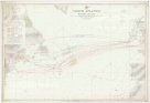 Mapová sbírka Přírodovědecké fakulty UK v PrazeNorth Atlantic route chart
 -
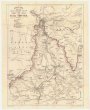
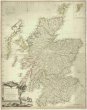 Mapová sbírka Přírodovědecké fakulty UK v PrazeNorth Britain or Scotland divided into its counties
 -
 Mapová sbírka Přírodovědecké fakulty UK v PrazeNorth polar chart
 -
 Mapová sbírka Přírodovědecké fakulty UK v PrazeNorth west Europe 1:250,000
 -
 Mapová sbírka Přírodovědecké fakulty UK v PrazeNorway to Iceland
 -
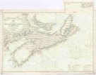 Mapová sbírka Přírodovědecké fakulty UK v PrazeNova Scotia, Prince Edward I and part of New Brunswick
 -
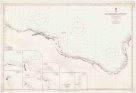
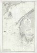
 Mapová sbírka Přírodovědecké fakulty UK v PrazeOdessa Bay
 -
 Mapová sbírka Přírodovědecké fakulty UK v PrazeOrdnance survey map of Guernsey
 -
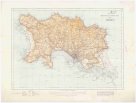 Mapová sbírka Přírodovědecké fakulty UK v PrazeOrdnance survey map of Jersey
 -
 Mapová sbírka Přírodovědecké fakulty UK v PrazeOrdnance survey of England and Wales
 -
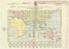 Mapová sbírka Přírodovědecké fakulty UK v PrazeOrient line between England & Australia
 -
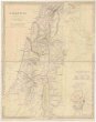 Mapová sbírka Přírodovědecké fakulty UK v PrazePalestine
 -
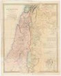 Mapová sbírka Přírodovědecké fakulty UK v PrazePalestine with the Hauran
 -
 Mapová sbírka Přírodovědecké fakulty UK v PrazePanama Canal
 -
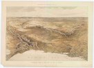 Mapová sbírka Přírodovědecké fakulty UK v PrazePanoramic view of the seat of war in Europe
 -
 Mapová sbírka Přírodovědecké fakulty UK v PrazePhilip's Plan of the town and port of Liverpool
 -
 Mapová sbírka Přírodovědecké fakulty UK v PrazePhilips' Railway Map of the British Isles
 -
 Mapová sbírka Přírodovědecké fakulty UK v PrazePhilips' large scale military map of the seat of war of the Natal frontier
 -
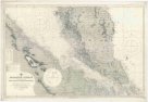
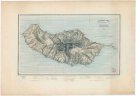 Mapová sbírka Přírodovědecké fakulty UK v PrazePhysical map of the island of Madeira
 -
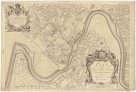
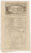
 Mapová sbírka Přírodovědecké fakulty UK v PrazePlan du jardin & vuë des maisons de Chiswick sur la Tamise a deux lieves de Londres
 -
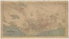 Mapová sbírka Přírodovědecké fakulty UK v PrazePlan of Dundee
 -
 Mapová sbírka Přírodovědecké fakulty UK v PrazePlan of the city & castle of Chester
 -
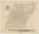
 Mapová sbírka Přírodovědecké fakulty UK v PrazePlan of the city of Dublin
 -
 Mapová sbírka Přírodovědecké fakulty UK v PrazePlan of the roads from Scarbro' Whitby, &c. to Sunderland, Schields, &c. through York, Durham, &c. and of that through Guisbro' Stockton, Castle Eden, &c.
 -
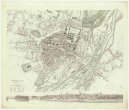
 Mapová sbírka Přírodovědecké fakulty UK v PrazePlzen
 -
 Mapová sbírka Přírodovědecké fakulty UK v PrazePlzen
 -
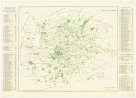
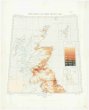 Mapová sbírka Přírodovědecké fakulty UK v PrazePopulation of Great Britain
 -
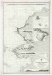
 Mapová sbírka Přírodovědecké fakulty UK v PrazePort Sudan
 -
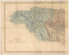
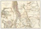
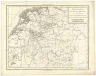 Mapová sbírka Přírodovědecké fakulty UK v PrazePossessions du roi de Prusse a l'ouest du Weser.
 -
 Mapová sbírka Přírodovědecké fakulty UK v PrazePublic open spaces
 -
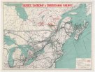 Mapová sbírka Přírodovědecké fakulty UK v PrazeQuebec, Saguenay & Chibougamau railway
 -
 Mapová sbírka Přírodovědecké fakulty UK v PrazeRed Sea
 -
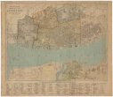
 Mapová sbírka Přírodovědecké fakulty UK v PrazeReynolds's map of modern London
 -
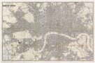 Mapová sbírka Přírodovědecké fakulty UK v PrazeReynolds's map of modern London
 -
 Mapová sbírka Přírodovědecké fakulty UK v PrazeRiver Amazon
 -
 Mapová sbírka Přírodovědecké fakulty UK v PrazeRiver Benin to river Cameroons
 -
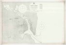
 Mapová sbírka Přírodovědecké fakulty UK v PrazeRiver Niger from Bussa to the sea
 -
 Mapová sbírka Přírodovědecké fakulty UK v PrazeRoad map of Great Britain