-
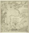 Mapová sbírka Přírodovědecké fakulty UK v PrazeThe seat of war on the coast of France being a new chart of the coast of Holland, Flanders, France, Spain & Portugal, with the adjacent islands, part of Barbary, England and Ireland
 -
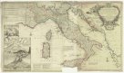 Mapová sbírka Přírodovědecké fakulty UK v PrazeA new map of Italy distinguishing all the sovereignties in it, whether states, kingdoms, dutchies, principalities, republicks & c.
 -
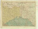 Mapová sbírka Přírodovědecké fakulty UK v PrazeA new and accurate map of Saxony, part of Brandenburg, Silesia, Poland and Bohemia
 -
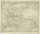 Mapová sbírka Přírodovědecké fakulty UK v PrazeGermany
 -
 Mapová sbírka Přírodovědecké fakulty UK v PrazeAthens
 -
 Mapová sbírka Přírodovědecké fakulty UK v PrazeThe world as known to the ancients
 -
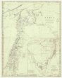
 Mapová sbírka Přírodovědecké fakulty UK v PrazeThe eastern part of the ancient Persian empire
 -
 Mapová sbírka Přírodovědecké fakulty UK v PrazeGrecian archipelago
 -
 Mapová sbírka Přírodovědecké fakulty UK v PrazeAncient Syria
 -
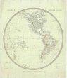 Mapová sbírka Přírodovědecké fakulty UK v PrazeWestern hemisphere
 -
 Mapová sbírka Přírodovědecké fakulty UK v PrazeHydrographical chart of the world on Wright or Mercator projection.
 -
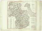 Mapová sbírka Přírodovědecké fakulty UK v PrazeCarte Générale des états du Roi de Sardaigne
 -
 Mapová sbírka Přírodovědecké fakulty UK v PrazeDenmark and part of Norway (Denmark, Norge)
 -
 Mapová sbírka Přírodovědecké fakulty UK v PrazeThe southern provinces of Sweden (Sverige)
 -
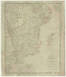
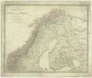 Mapová sbírka Přírodovědecké fakulty UK v PrazeThe northern provinces of Sweden and Norway with part I, of Russia
 -
 Mapová sbírka Přírodovědecké fakulty UK v PrazeLondon
 -
 Mapová sbírka Přírodovědecké fakulty UK v PrazeHamp Shire ; Berk Shire ; Wilt Shire
 -
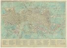 Mapová sbírka Přírodovědecké fakulty UK v PrazeBowles's reduced new pocket plan of the cities of London
 -
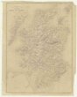
 Mapová sbírka Přírodovědecké fakulty UK v PrazeNorth Britain or Scotland divided into its counties
 -
 Mapová sbírka Přírodovědecké fakulty UK v PrazeCarte physique et routiere de l'Ecosse
 -
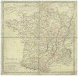 Mapová sbírka Přírodovědecké fakulty UK v PrazeFrance in provinces
 -
 Mapová sbírka Přírodovědecké fakulty UK v PrazeA chart of the Canary islands, including Madeira
 -
 Mapová sbírka Přírodovědecké fakulty UK v PrazeBalearic islands ; Corsica, and Sardinia ; Valetta, the capital of Malta
 -
 Mapová sbírka Přírodovědecké fakulty UK v PrazeSwitzerland